
Gulshan Empire Master Plan — 6 Towers on 5.56 Acres
Gulshan Empire places six G+31 towers and approx. 496–500 residences around a central green on 5.56 acres (22,504 sq m) at Wave City, Sector 1, NH-24, Ghaziabad — a low-density, landscape-led site plan. Below: the tower disposition A–F, the density math, the township road frontage and what the official master plan legend shows.
Project RERA: UPRERAPRJ166511/05/2026 (as filed by the developer) · Verify on up-rera.in
Marketed by Vidastu Advisory · UP-RERA Agent UPRERAAGT000309/01/2026 · No buyer-side fees
The Gulshan Empire master plan, by Gulshan Empire Estate LLP, shows six G+31 towers and approx. 496–500 residences arranged around a central landscaped green on 5.56 acres (22,504 sq m) at Wave City, Sector 1, NH-24, Ghaziabad — a density of roughly 89 units per acre (computed), which reads as low-density for a high-rise. The RERA filing registers a community building (~2,846 sq m) and a park; the plot fronts the township's 60 m and 30 m roads. Project RERA: UPRERAPRJ166511/05/2026 (as filed by the developer). Note: third-party listings that claim "4 towers" or "550 units" are incorrect — the RERA-filed configuration is 6 towers and approx. 496–500 residences. Last updated: 9 June 2026.
One Plot, Read in Numbers.
A master plan is a project's argument for how you will live in it. Gulshan Empire's argument is space: six tall towers on a compact 5.56-acre footprint, so the ground plane can stay open and green rather than packed with low-rise blocks.
The hard, RERA-filed numbers are below. The land is 5.56 acres — 22,504 sq m. The towers number six, each G+31. The residence count sits at approx. 496–500. Within the boundary, the filing registers a single community building of about 2,846 sq m and a landscaped park, sitting alongside the project's roads, parking and utility infrastructure. Everything else you read on a marketing layout — pools, courts and the like — is conceptual until the brochure and sanctioned plan confirm it.
| Master-plan metric | Value |
|---|---|
| Site area | 5.56 acres (22,504 sq m) |
| Towers | 6 (Towers A–F) |
| Height | G+31 each |
| Residences | approx. 496–500 |
| Configurations | 3 BHK+SR & 4 BHK+SR only |
| Community building (RERA-filed) | ~2,846 sq m |
| Park / greens (RERA-filed) | landscaped open space |
| Density (computed) | ~89 units / acre |
Structural figures as filed with UP-RERA; density is computed (see Section III). Amenity content beyond the community building & park is conceptual. Full project guide →
Six Towers, Pushed to the Edges.
The single most important move on this master plan is where the towers sit. Placing all six — referenced here as Towers A to F — toward the perimeter of the plot frees the centre for landscape, and gives most apartments an outward outlook instead of a face-off with the next tower.
| Tower | Height | Indicative position |
|---|---|---|
| Tower A | G+31 | north-west cluster |
| Tower B | G+31 | north / frontage edge |
| Tower C | G+31 | north-east cluster |
| Tower D | G+31 | south-east cluster |
| Tower E | G+31 | south / frontage edge |
| Tower F | G+31 | south-west cluster |
Tower naming and positions are indicative, for orientation only; the official master plan and GDA-sanctioned layout are authoritative.
A perimeter arrangement does several things at once. It opens up sight-lines from the apartments across the central green rather than into a neighbour's living room. It lets the wide township road frontage take visitor and drop-off traffic at the edges, keeping the core calm and walkable. And it concentrates the shared amenity — the clubhouse and the landscaped heart — at the centre, equidistant from each tower, so no tower is the "back" of the project.
Because every tower is G+31 rather than a sprawl of mid-rises, the building footprints stay small for the number of homes they hold. That is the trade the plan makes deliberately: go tall on a tight footprint, and spend the saved ground on open space. Corner and double-aspect units within each tower tend to win most on light, cross-ventilation and view — confirm a specific unit's aspect on its floor plan.
Why It Reads as Low-Density.
Density is the quiet number behind quality of life — how many homes share the same ground, lobbies, lifts and roads. Here is the arithmetic, shown openly so you can check it yourself.
Take the residence count of approx. 496–500 and divide by the 5.56-acre site area. That gives roughly 89 units per acre. This figure is computed by us from the unit count and site area — it is not a number the developer states. For a G+31 high-rise, ~89 units per acre is a moderate, comparatively low-density figure: the height absorbs the homes so the ground stays open. Final ground coverage, FAR and the precise open-space ratio are governed by the plan sanctioned with UP-RERA.
| Step | Value |
|---|---|
| Residences | ~496–500 |
| Site area | 5.56 acres |
| Units per acre (computed) | ~89 |
| Tower count | 6 |
| Residences per tower (computed) | ~83 avg |
| Building height | G+31 |
Per-acre and per-tower figures are computed from the RERA-filed unit count and site area; treat as indicative. Final densities per the sanctioned plan.
Watch: why this reads as low-density, in about a minute
Six towers (G+31) and approximately 496–500 residences spread across 5.56 acres — what that density actually feels like on the ground, in Wave City, Sector 1, on the NH-24 corridor. The 60-second version of this section.
From the Vidastu Advisory YouTube channel. Visuals include builder renders & artistic visualization — not actual site footage. Watch on YouTube →
On a 60-Metre Frontage.
A master plan is only as good as the roads that reach it. Gulshan Empire's plot fronts Wave City's internal road hierarchy — a 60-metre-wide master-plan arterial and 30-metre-wide roads — which in turn feed onto NH-24, the Delhi–Meerut Expressway.
Wide frontage is not just an aesthetic. A 60 m arterial gives clear, unobstructed approach to the gate, room for visitor and drop-off movement without choking the entry, and the turning radius that fire tenders and emergency vehicles need. The 30 m roads distribute traffic around the township so the project's own gate is not the only pressure point. Inside the boundary, the project's internal driveways and the fire-tender loop are defined on the GDA-sanctioned layout.
Because the township grid is planned rather than retrofitted, the road widths are consistent and the connections to the expressway are direct — part of why the Wave City master plan, a ~4,200-acre IGBC pre-certified Platinum township, frames this address the way it does. For the full connectivity picture — EPE, RRTS and the Jewar airport timeline — see the location page.
Explore location & connectivity →| Frontage / road | Indicative width |
|---|---|
| Township master-plan arterial | 60 m wide |
| Secondary township roads | 30 m wide |
| Connects onto | NH-24 / Delhi–Meerut Expressway |
| Internal driveways | per GDA-sanctioned layout |
| Fire-tender access | per sanctioned plan |
Road widths are the township's planned dimensions; the project's internal road and fire-access detail are defined on the official sanctioned plan.
A Green Centre, Not a Filled One.
With the towers at the edges, the centre of the plan is given over to landscape and shared life. The RERA filing anchors this with a registered community building and a park; the developer's master plan layers a conceptual amenity programme on top.
| Open-space element | Status |
|---|---|
| Central landscaped green | core of the layout |
| Community building / clubhouse | ~2,846 sq m (RERA-filed) |
| Landscaped park | RERA-filed |
| Pool, courts, play zones | per the developer's brochure & master plan (conceptual) |
| Surface & structured parking | per sanctioned plan |
Only the community building and park are confirmed in the RERA filing; all other amenity content is conceptual until the brochure. Full amenities page →
Orienting the project inward — towards a green core rather than a built one — is what gives a high-rise its sense of calm. The clubhouse sitting at the heart means it is reachable on foot from every tower along landscaped paths, not across a car park. The park and green absorb the visual weight of the towers, so the experience at ground level is of openness rather than density, even at ~89 units per acre.
We are deliberately careful with the amenity list. The RERA filing confirms a community building of about 2,846 sq m and a landscaped park, plus the infrastructure a project of this size requires. Pools, courts, play zones and the rest appear on marketing layouts and are plausible for this segment, but they are conceptual — and inconsistent across third-party sites — until the official brochure and sanctioned plan fix them. We would rather you book on what is filed than on what is rendered.
The Master Plan Legend, in Full.
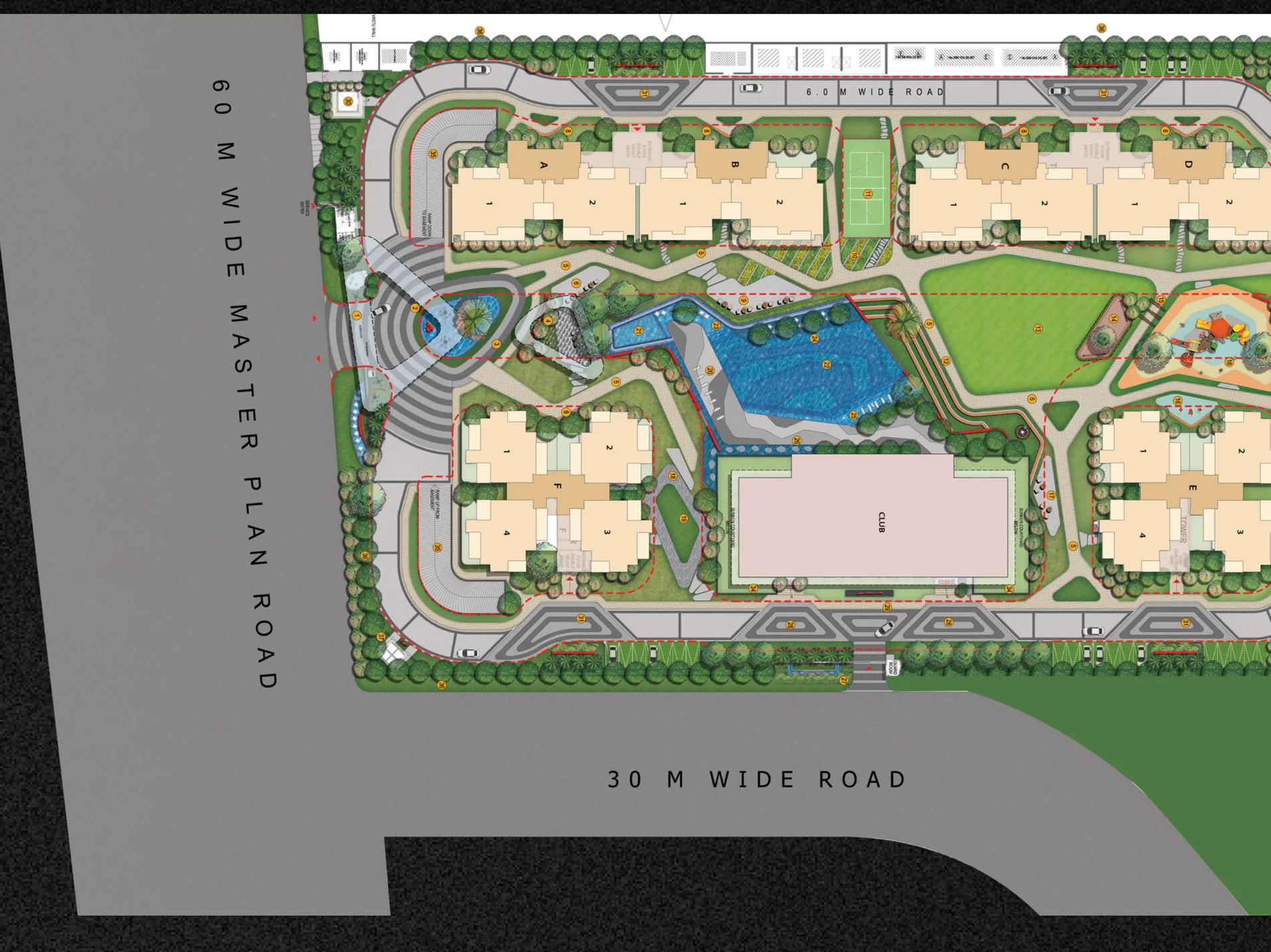
The developer's master plan (shown at the top of this page) is a professionally rendered landscape drawing with a numbered amenities legend, the six towers around the central Gulshan Club and greens, and the labelled "60 M WIDE" master-plan road and "30 M WIDE" road frontage. It carries the developer's standard "purely conceptual" disclaimer. Below is the full 36-point legend as keyed on the official sheet — the developer's master-plan amenity layer, conceptual intent rather than a guaranteed schedule.
- Entrance Gate Complex
- Grand Entrance Water Feature with Sculpture
- Entrance Plaza
- Kinetic Feature Wall
- Soft Angular Pathway / Jogging Track
- Pavilion with Viewing Deck Above
- Sculptural Leaf Seat
- Angular Seats Along Pathway in Greens
- Seating Along Infinity Edge
- Aroma Garden
- Pickleball Court
- Open Air Theater
- Multipurpose Lawn
- Garden Pavilion
- Pathway Through Portals
- Kid's Play Area
- Seating with Plantation in Backdrop
- Reflexology Garden
- Yoga Lawn
- Covered Pool Deck with Water Fall
- Kid's Pool with Playful Spouts
- Pool with Infinity Edge
- Interactive Shallow Water Feature with Nozzles
- Water Feature at Infinity Edge with Floating Planters and Nozzles
- In-Pool Loungers
- Water Feature with Sculptural Elements
- Club Signage with Water Feature at the Entrance
- Club / Banquet Drop-Off
- Grand Sculpture in Greens at Club Entrance
- Temple Complex
- Tower Drop-Off with Tower Signage Floating in Greens and Palm Trees in Backdrop
- Half Basketball Court
- Cricket Net Practice
- Skating Rink
- Drooping Greens Along Ramp
- Boundary Plantation
The 36-point legend is the developer's master-plan amenity layer (purely conceptual), laid over the RERA-filed base of a community building (~2,846 sq m) and landscaped park. Use the plan to orient yourself, then verify binding facts on the approved layout filed with UP-RERA, the GDA sanction and the Agreement for Sale, which govern what is actually built.
We negotiate for you. Through Vidit we push the developer for early-bird and unit-specific deals on your behalf — no buyer-side fees. Current pricing →
On the official sheet, look for
Tower footprints A–F
The six towers ranged around the plot; confirm the actual naming and exact positions against this sheet.
Central Gulshan Club & green
The community building and landscaped heart at the centre — cross-check the ~2,846 sq m figure with the RERA filing.
Numbered amenity legend
Landscape and amenity zones (1–36, above) keyed to numbers; read these as conceptual intent, not a fixed schedule.
60 m / 30 m road labels
The master-plan road and the 30 m road frontage, plus the entrance gate along the plot edges.
Legend transcribed from the developer's brochure master-plan rendering; only the community building & park are RERA-filed. The sanctioned plan on up-rera.in is authoritative.
See the Gulshan Empire Master Plan.
The official master plan and site layout — the six towers, the central clubhouse and green, the numbered legend and the road frontage — sent personally on WhatsApp in minutes, alongside both floor plans and the cost sheet if you'd like.
Read the site with the rest: the floor plans, the amenities, the price breakdown and the location — or start with the project guide.
Request the Master Plan
Site layout + both floor plans, on WhatsApp in minutes.
On the way!
Vidit will send the master plan and floor plans to your WhatsApp within minutes.
By submitting you consent to be contacted about this project and to your details being shared with the RERA-registered promoter. No spam · no buyer-side fees.
Gulshan Empire Master Plan — FAQ
What does the Gulshan Empire master plan show?
The Gulshan Empire master plan shows six residential towers of G+31, holding approx. 496–500 residences, arranged around a central landscaped green on a 5.56-acre (22,504 sq m) site at Wave City, Sector 1, NH-24, Ghaziabad. The RERA filing registers a community building of about 2,846 sq m and a landscaped park; the layout fronts the township's 60 m and 30 m roads. Project RERA: UPRERAPRJ166511/05/2026 (as filed by the developer).
How many towers are there in Gulshan Empire and how are they arranged?
There are six towers, usually referenced as Towers A to F, each rising G+31 (ground plus 31 floors). On the master plan they are placed around the edges of the 5.56-acre site so that the centre is freed up for a landscaped green and the community clubhouse. This peripheral tower placement is what keeps the layout low-density and gives most apartments an open outlook rather than facing another tower head-on. Confirm the exact tower count, naming and positions on the developer's official master plan.
What is the density of Gulshan Empire?
Gulshan Empire holds approx. 496–500 residences on 5.56 acres, which works out to roughly 89 units per acre — a figure we have computed by dividing the unit count by the site area, not a developer-stated number. For a G+31 high-rise this is a moderate, comparatively low-density figure, achieved by going taller on a smaller footprint and keeping the ground plane open. Final densities and ground coverage are governed by the sanctioned plan filed with UP-RERA.
Does Gulshan Empire have 4 towers or 550 units?
No. Some third-party listings circulate figures such as "4 towers" or "550 units" for Gulshan Empire — these are incorrect. As filed with UP-RERA (Project RERA UPRERAPRJ166511/05/2026), Gulshan Empire is 6 towers (Towers A–F), each G+31, holding approx. 496–500 residences on 5.56 acres — roughly 89 units per acre (computed). Always verify the tower and unit count against the developer's official master plan and the sanctioned plan on up-rera.in, which are authoritative.
How wide are the roads at Gulshan Empire in Wave City?
The Gulshan Empire plot fronts Wave City's internal master-plan road network, which includes a 60-metre-wide arterial road and 30-metre-wide roads. This township road hierarchy feeds directly onto NH-24 / the Delhi–Meerut Expressway. The wide frontage supports clear approach, visitor movement and emergency access. Exact frontage widths and the project's own internal driveways are defined on the official site plan and the GDA-sanctioned layout.
Can I see the official Gulshan Empire master plan?
Yes — the developer's brochure master plan is shown at the top of this page, with the six towers around the central Gulshan Club and greens, the infinity-edge pool, the full 36-point amenity legend and the 60 m and 30 m road frontage. It is a conceptual artist's rendering; only the community building (~2,846 sq m) and landscaped park are registered in the RERA filing, and the GDA-sanctioned layout governs what is built. For the high-resolution master plan alongside both floor plans and the cost sheet, call or WhatsApp Vidit Kaushik at +91 98114 05300 or submit the form on this page.